Turn data into insight with iipmaps: effortless, professional mapping for everyone.
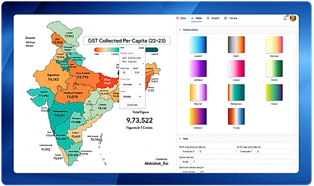
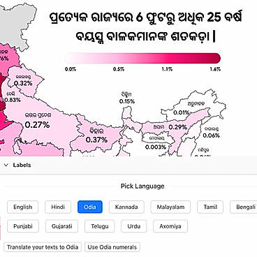
Iipmaps is an innovative AI-powered platform that streamlines the processes of data visualization and mapping, catering to users with no coding or GIS expertise. This no-code solution empowers individuals and teams to convert complex datasets into professional, presentation-ready maps efficiently—typically within minutes. The platform features an intuitive drag-and-drop interface that facilitates seamless customization, making it particularly suited for marketers, strategists, sales operations, government organizations, and enterprise teams. Creating a map involves a straightforward three-step process: uploading the data, styling the map with customizable palettes and annotations, and exporting the final product as a PNG or SVG file in either high or low resolution. iipmaps includes a suite of powerful features, such as fully customizable color palettes for branding, multi-language support for a global reach, and flexible editing tools for scaling and merging regions as well as adding images and notes. By eliminating the complexities associated with traditional GIS software, iipmaps empowers users to craft dynamic, high-quality maps that effectively communicate their data insights, thereby transforming raw information into engaging visual narratives that inform and inspire audiences.
Read more
Pricing
Platforms Supported
Organization Types Supported
API Support
Modes of Support
Map Sharing
Allows exchanging the created maps with others for better collaborationMap Creation
Helps in creating maps using less effort and in less timeLabeling
Supports attaching labels to certain items for its quick and easy identificationInternet Mapping
Allows to store and display Internet topological data in a systematic wayImage Management
Automates the graphical data management and monitoring tasks for easy accessibilityImage Exporting
Supports export of graphical data at different sizes and formatGeocoding
Enables users to convert an address into spatial data to find the coordinates of an address or placeColor Coding
Allows highlighting different significant information by using different colors for easy identification3D Imagery
Supports stereoscopic imaging where a technique is used to record and display images by creating an illusion of depth in themSpatial Analysis
Supports manipulation of geographical data or imagery for better geovisualization in a different context, applications, and operationsInteroperability
This feature enables the system to share resources with other system/software and make good use of the exchanged dataCensus Data Integration
Helps to collect census data from multiple sources and display it in a unified form in a single databaseFree Trial
Available
Pricing Plans
Pro Others
₹8999 Per Year
₹899 Per Month
Features
Enterprise Custom
Features
Screenshots of Vendor Pricing Page

Learn more about iipmaps Pricing
98% SW Score The SW Score ranks the products within a particular category on a variety of parameters, to provide a definite ranking system. Read more
96% SW Score The SW Score ranks the products within a particular category on a variety of parameters, to provide a definite ranking system. Read more
93% SW Score The SW Score ranks the products within a particular category on a variety of parameters, to provide a definite ranking system. Read more
92% SW Score The SW Score ranks the products within a particular category on a variety of parameters, to provide a definite ranking system. Read more
91% SW Score The SW Score ranks the products within a particular category on a variety of parameters, to provide a definite ranking system. Read more
90% SW Score The SW Score ranks the products within a particular category on a variety of parameters, to provide a definite ranking system. Read more
90% SW Score The SW Score ranks the products within a particular category on a variety of parameters, to provide a definite ranking system. Read more
90% SW Score The SW Score ranks the products within a particular category on a variety of parameters, to provide a definite ranking system. Read more
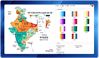
Assets Created Map
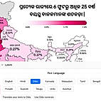
Seamless Multi-La...
What is iipmaps used for?
iipmaps is Geographic Information System Software. iipmaps offers the following functionalities:
Learn more about iipmaps features.
What are the top alternatives for iipmaps?
Here`s a list of the best alternatives for iipmaps:
Does iipmaps provide API?
No, iipmaps does not provide API.
Vendor Details
Odisha, India - 768201Social Media Handles
This research is curated from diverse authoritative sources; feel free to share your feedback at feedback@saasworthy.com
Looking for the right SaaS
We can help you choose the best SaaS for your specific requirements. Our in-house experts will assist you with their hand-picked recommendations.
Want more customers?
Our experts will research about your product and list it on SaaSworthy for FREE.