Capture the actual reality irrespective of the altitude, from any angle
Free Trial
Available
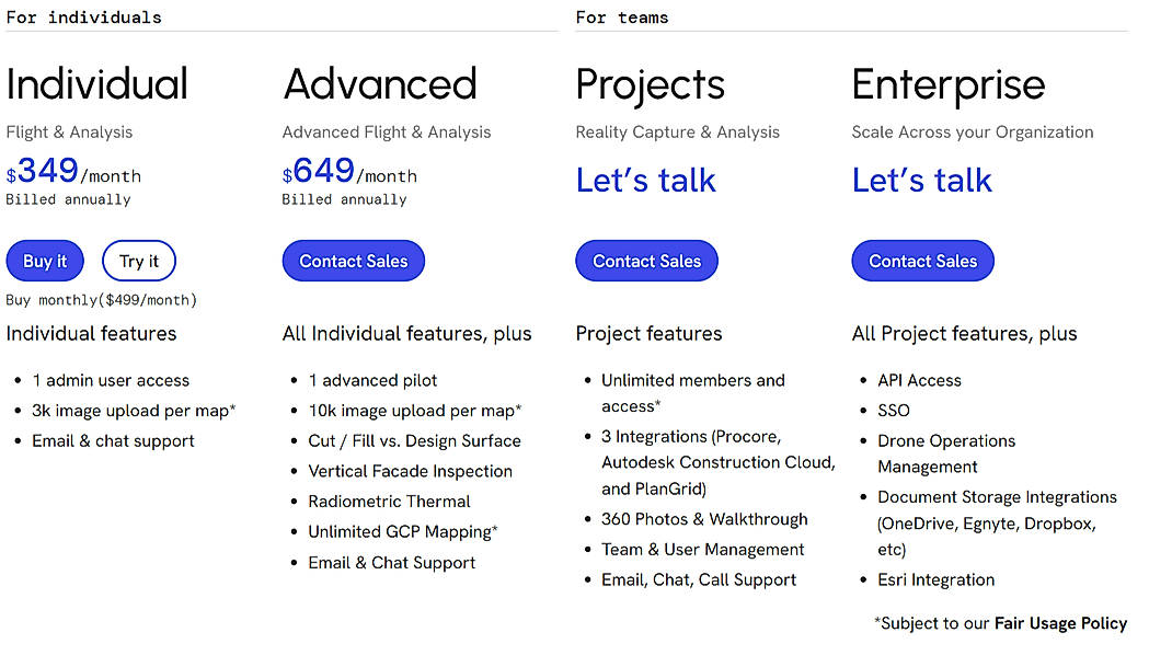
Individual (Construction) $349.00 $499.00 per month
For Individuals
$349 Per Month Billed Annually
$499 Per Month Billed Monthly
Features
Advanced (Construction) $649.00 $649.00 per month
For Individuals
$649 Per Month Billed Annually
Features
Projects (Construction) Custom
For Teams
Features
Enterprise (Construction) Custom
For Teams
Features
Individual (Energy) $349.00 $499.00 per month
For Individuals
$349 Per Month Billed Annually
$499 Per Month Billed Monthly
Features
Advanced (Energy) $649.00 $649.00 per month
For Individuals
$649 Per Month Billed Annually
Features
Teams (Energy) Custom
For Teams
Features
Enterprise (Energy) Custom
For Teams
Features
Ag Lite (Agriculture) $159.00 $159.00 per month
For Individuals
$159 Per Month Billed Annually
Features
Individual (Agriculture) $349.00 $499.00 per month
For Individuals
$349 Per Month Billed Annually
$499 Per Month Billed Annually
Features
Teams (Agriculture) Custom
For Teams
Features
Enterprise (Agriculture) Custom
For Teams
Features
Individual (Property Management) $349.00 $499.00 per month
For Individuals
$349 Per Month Billed Annually
$499 Per Month Billed Monthly
Features
Advanced (Property Management) $649.00 $649.00 per month
For Individuals
$649 Per Month Billed Annually
Features
Property Enterprise (Property Management) Custom
For Teams
Features
Individual (Others) $349.00 $499.00 per month
For Individuals
$349 Per Month Billed Annually
$499 Per Month Billed Monthly
Features
Advanced (Others) $649.00 $649.00 per month
For Individuals
$649 Per Month Billed Annually
Features
Teams (Others) Custom
For Teams
Features
Enterprise (Others) Custom
For Teams
Features
Screenshots of Vendor Pricing Page

How much does DroneDeploy cost?
The pricing for DroneDeploy starts at $159.0 per month. DroneDeploy has 10 different plans:
DroneDeploy also offers a custom plan based on the customer's request.
Learn more about DroneDeploy pricing.
Does DroneDeploy offer a free plan?
No, DroneDeploy does not offer a free plan.
Learn more about DroneDeploy pricing.
| Product Name | Starting Price ($) | Billed | Unit | Free Trial | Learn More |
|---|---|---|---|---|---|
|
|
159 | per month | - | DroneDeploy Pricing | |
|
|
- | - | - | Site Scan for ArcGIS Pricing | |
|
|
- | - | - | SURE Aerial Pricing | |
|
|
291.67 | per month | - | Pix4Dcapture Pricing | |
|
|
- | - | - | PrecisionAnalytics Pricing | |
|
|
19 | per month | - | CloudPano Pricing | |
|
|
45 | per month | - | Recap Pro Pricing | |
|
|
1 | - | - | CAPTUR3D Pricing | |
|
|
- | - | - | Concept3D Pricing | |
|
|
1 | - | - | Online Check Writer Pricing |
72% SW Score The SW Score ranks the products within a particular category on a variety of parameters, to provide a definite ranking system. Read more
Color Coding
Allows highlighting different significant information by using different colors for easy identificationSpatial Analysis
Supports manipulation of geographical data or imagery for better geovisualization in a different context, applications, and operationsCensus Data Integration
Helps to collect census data from multiple sources and display it in a unified form in a single databaseInteroperability
This feature enables the system to share resources with other system/software and make good use of the exchanged dataLabeling
Supports attaching labels to certain items for its quick and easy identificationGeocoding
Enables users to convert an address into spatial data to find the coordinates of an address or placeMap Creation
Helps in creating maps using less effort and in less timeImage Management
Automates the graphical data management and monitoring tasks for easy accessibility3D Imagery
Supports stereoscopic imaging where a technique is used to record and display images by creating an illusion of depth in themMap Sharing
Allows exchanging the created maps with others for better collaborationImage Exporting
Supports export of graphical data at different sizes and formatInternet Mapping
Allows to store and display Internet topological data in a systematic wayLooking for the right SaaS
We can help you choose the best SaaS for your specific requirements. Our in-house experts will assist you with their hand-picked recommendations.
Want more customers?
Our experts will research about your product and list it on SaaSworthy for FREE.