Field operations made easy
ArcGIS GeoEvent Server tracks changing dynamic resources such as vehicles, aircraft, and ships, or static resources such as weather sensors and environmental monitoring sensors. It provides real-time situational awareness for coordinated field operations.ArcGIS GeoEvent Server provides the real-time situational awareness needed for mission-critical operations. The GeoEvent server allows the control center to monitor the real-time status of field installations. Moreover, they can analyze events and moreover users can also predict future trends and make better decisions.provides it to employers. You can use them to retrieve data from any device and display it on a map. Analyzing multiple data streams in one place gives GeoEvent Server an edge over other coexisting technologies.Seamless integration of IoT with GIS in a simple approach. The GIS application is now updated with real-time attribute information. The campus vehicle tracking system is also enhanced using the latest real-time vehicle location.
Read more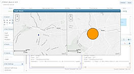
Pricing
Platforms Supported
Organization Types Supported
API Support
Modes of Support
Monitoring
Helps to monitor the database content and data accessibility in an automated and orderly mannerReal-time Activity Tracking
Enables tracking the status of online bidders along with their activities, etc.Asset Tracking
Tools a company uses to run its businessReal Time Analytics
Facilitates analyzing the data rightly as soon as the data enters the systemLocation Tracking
Helps in finding the real-time location of the userFree Trial
Not available
ArcGIS GeoEvent Server Custom
Features
Disclaimer: The pricing details were last updated on 28/12/2020 from the vendor website and may be different from actual. Please confirm with the vendor website before purchasing.
Learn more about ArcGIS GeoEvent Server Pricing
89% SW Score The SW Score ranks the products within a particular category on a variety of parameters, to provide a definite ranking system. Read more
90% SW Score The SW Score ranks the products within a particular category on a variety of parameters, to provide a definite ranking system. Read more
77% SW Score The SW Score ranks the products within a particular category on a variety of parameters, to provide a definite ranking system. Read more
86% SW Score The SW Score ranks the products within a particular category on a variety of parameters, to provide a definite ranking system. Read more
92% SW Score The SW Score ranks the products within a particular category on a variety of parameters, to provide a definite ranking system. Read more
81% SW Score The SW Score ranks the products within a particular category on a variety of parameters, to provide a definite ranking system. Read more

GeoEvent Server: ...
ArcGIS GeoEvent S...
ArcGIS GeoEvent S...

Event Viewer
What is ArcGIS GeoEvent Server used for?
Learn more about ArcGIS GeoEvent Server features.
Does ArcGIS GeoEvent Server provide API?
Yes, ArcGIS GeoEvent Server provides API.
Vendor Details
Noida, IndiaSocial Media Handles
Not available
This research is curated from diverse authoritative sources; feel free to share your feedback at feedback@saasworthy.com
Looking for the right SaaS
We can help you choose the best SaaS for your specific requirements. Our in-house experts will assist you with their hand-picked recommendations.
Want more customers?
Our experts will research about your product and list it on SaaSworthy for FREE.

